


Forager's Buddy - GPS foraging
Perihal Forager's Buddy - GPS foraging
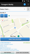
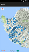
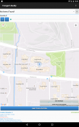
Forager's Buddy ialah aplikasi percuma untuk telefon pintar dan tablet android, direka untuk membantu pengguna menandai pada peta semua tempat yang menarik, di mana mereka boleh menemui pelbagai jenis sumber makanan liar (Menggunakan modul GPS peranti).
Anda boleh menggunakan aplikasi mencari makanan ini dalam pelbagai aktiviti luar seperti pengumpulan herba/cendawan liar, memburu, memancing, berkhemah, mendaki, dsb.
Penting: Android 10+ mempunyai tetapan kebenaran lokasi baharu. Untuk rakaman laluan Forager's Buddy berfungsi dengan baik, anda mesti memilih pilihan "Benarkan sepanjang masa" (daripada Maklumat aplikasi -> Kebenaran aplikasi -> Lokasi).
Panduan Rujukan Pantas Forager’s Buddy [PDF] - https://bit.ly/3usgDt6
Tutorial Pantas Forager’s Buddy 1 [Video] - https://youtu.be/jWCD6dVO3II
Tutorial Pantas Forager’s Buddy 2 [Video] - https://youtu.be/s9DHd6lT160
Tutorial Pantas Forager’s Buddy 3 [Video] - https://youtu.be/2TmSqWIxSC0
Tutorial Pantas Forager’s Buddy 4 [Video] - https://youtu.be/f-jYRJls89Q
Tutorial Pantas Forager’s Buddy 5 [Video] - https://youtu.be/Ssx1a3Y-C1I
Sila beritahu kami tentang perubahan yang anda ingin lihat dalam Forager's Buddy.
Ciri-ciri (Edisi percuma):
1. Pemilihan antara unit sistem imperial dan metrik
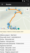
2. Rakaman & tontonan laluan (Mengeksport laluan sebagai format fail .kml)**. Terdapat keupayaan untuk melihat tempat berdekatan dan menukar fail laluan .kml kepada format .gpx
3. Mengeksport dan Mengimport data sebagai CSV.
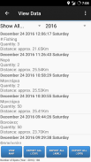
4. Penapisan Data.
5. Lampirkan foto pada lokasi
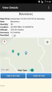
6. Melihat anggaran jarak setiap item dari lokasi semasa pengguna.
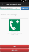
7. Panggilan Kecemasan dan SMS (Menghantar SMS dengan lokasi terakhir diketahui pengguna dan status bateri peranti).
8. Kegemaran.
9. Perkongsian Lokasi Item (cth. melalui E-mel atau SMS).
10. Perkongsian Lokasi Semasa (cth. melalui E-mel atau SMS).
11. Perkongsian fail CSV (cth. melalui E-mel atau Bluetooth).
12. Perkongsian fail laluan KML (cth. melalui E-mel atau Bluetooth).
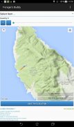
13. Lokasi Tersuai. Pengguna boleh menyimpan tempat tersuai dari skrin utama, dengan mengklik lama pada lokasi yang dikehendaki pada peta.
14. Autosandar (eksport ke .csv) setiap kali pengguna membuat perubahan.
15. Tema gelap
16. Anda boleh mencari dengan mudah apa yang hendak dimakan dalam bulan semasa (berdasarkan penemuan terdahulu anda)
Ciri-ciri (edisi Pro):
1. Semua ciri edisi percuma / bebas iklan
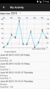
2. Aktiviti Saya. Perwakilan grafik bilangan item yang dikumpul setiap bulan.
3. Radar. Memaparkan peta dan senarai item yang dikumpul oleh pengguna. Peta disegarkan setiap 3 saat. Julat radar boleh laras: 0 – 1000 meter.
4. Lokasi Tersuai. Pengguna boleh menyimpan tempat tersuai dari skrin "Lihat Peta", dengan mengklik lama pada lokasi yang dikehendaki pada peta.
5. Keadaan cuaca semasa untuk lokasi item semasa dan disimpan.
6. Eksport data ke format fail .kml (Pengguna yang menggunakan alatan seperti Google My Maps, boleh menggunakan ciri ini untuk membuat peta tersuai untuk tapak web atau blog mereka).**
7. Eksport data ke format fail .gpx.
8. Cari Nota.
9. Buat Peringatan dalam Kalendar.
10. Tunjukkan tempat berdekatan (dalam skrin Tunjukkan butiran item).
Fail yang dieksport oleh Forager's Buddy (.csv, .gpx dan .kml), boleh diimport dengan mudah dalam Perisian GIS (Sistem Maklumat Geografi) (seperti QGIS), untuk analisis data geografi selanjutnya.
Keizinan:
1. Kenalan/Telefon - Untuk ciri "Panggilan/SMS Kecemasan". Pengguna boleh memilih kenalan untuk dihubungi atau menghantar SMS sekiranya berlaku situasi kecemasan (ia juga menghantar lokasi terakhir pengguna yang diketahui dan status bateri peranti)
2. Lokasi - Atas sebab yang jelas :)
3. Storan - Untuk menyimpan fail yang dieksport seperti: spot (.kml, .csv), laluan (.kml) dan foto
Adakah anda seorang blogger atau wartawan? Minta Kod Promosi Google Play untuk menguji edisi Forager's Buddy PRO! https://goo.gl/ufpt7M
** KML ialah format fail yang digunakan untuk memaparkan data geografi dalam penyemak imbas Earth seperti Google Earth, Peta Google dan Peta Google untuk mudah alih.
Forager's Buddy - GPS foraging - Versi 3.8.5
(28-06-2025)Forager's Buddy - GPS foraging - Maklumat APK
Versi APK: 3.8.5Pakej: com.gh_its.foragersbuddyVersi Terkini Forager's Buddy - GPS foraging
Versi lain


Aplikasi dalam kategori sama


